 |
 |
 |
 |
 |
 |
53° North |
Richard Bell's Wild West Yorkshire nature diary, Thursday, 14th June, 2007 |
|
WELCOME
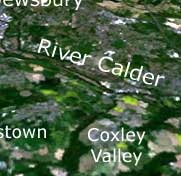
TO MY WORLD; Barbara and I live the lower end of Coxley Valley,
by the tail-end of that crescent
of woodland to the east of Middlestown, at longitude 53.65351
degrees north, latitude 1.57846 degrees west, to be precise.
Coxley Beck flows into the River Calder at Horbury Bridge. You can just make out two parallel watercourses (left); the lower of which is the Calder & Hebble Navigation, Horbury Cut, which runs to the south of the river here. This section of the navigation opened in 1838 but work on the navigation had started in the previous century.
A
mile or two downstream, the navigation joins the river which flows under the
M1 motorway, which is just visible as a snaking grey line (right) in
this satellite photogaph. Pugneys, once a marshy riverside
floodland, was dug first for sand and gravel, then, going deeper, for coal
in the 1970s and that dark indigo patch is
the lake (in fact two lakes; one for watersports, one for wildlife) which now
fills the excavation.
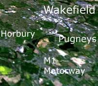
A new lake, the result of gravel extraction, between Horbury and Pugneys will extend the wildlife interest. In this photograph you can still see the excavations, showing as a sandy patch. The M1 bisects Millfield Lagoon (a dark triangle), the result of yet another sand quarry. In the extreme top right corner, behind the 'ld' of 'Wakefield' is the grey patch of the Welbeck waste disposal site, formerly an area of pitheaps, opencast mines and pulverised flyash (from Wakefield power station) settlement lagoons.
Sheds
and Spoil HeapsLooking towards Wetherby (left) and the north-eastern end of the Vale of York, there are two conspicuous white patches to the north of Wakefield. The bright white patch on the left is an industrial estate by the M1, the Junction 41 Estate. What a shame those sheds weren't built with grass roofs and that they weren't surrounded by grassy embankments as they're as conspicuous, on their ridge-top setting, from the surrounding countryside as they are as seen from space.
The large greyish patch on the right is Swillington opencast coal mine, soon to become a large Royal Society for the Protection of Birds wetlands reserve. Years ago the riverbank collapsed adjacent to the excavations and the waters of the River Aire flowed in, creating a deep lake. Chinook helicopters dropped sandbags into the breach to no avail. As luck would have it the giant excavator they were using wasn't at the bottom of the hole at the time of the flood. It took months of pumping and a river diversion approved by Act of Parliament to drain the lake.
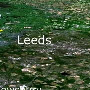
The
Rhubarb TriangleBetween Wakefield, Morley and Leeds there's an area known as the Rhubarb Triangle (right). Rich soils favoured the crop which, because of its large glossy leaves, could grow in the smoky atmosphere of the then industrial West Riding. It was forced rhubarb, grown in the dark in sheds, which was the cash crop. This was shipped to London via train. Wool waste, from the local textiles industry, was used as a soil conditioner in the fields.
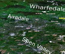
SUNWAC is the mnemonic for remembering the rivers of the Yorkshire
Dales (Swale,
Ure, Nidd, Wharfe, Aire and Calder). On the photograph above
the three southerly Dales and the Spen Valley tributary to
the Calder are visible. With this drainage pattern and textile towns - one
joining
onto the next -
squeezed into the valleys, it's no wonder that, after
a lifetime of living here, there are parts of West Yorkshire just a few
miles from home I'm still hazy about.
Below the 'W' in 'Wharfedale' is the brown plateau of Rombalds Moor of which Ilkley Moor forms a part.
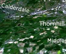
CalderdaleFinally (right), completing this anti-clockwise tour, Mirfield and Ravensthorpe lie in the Calder Valley to the west of Thornhill (exactly where Calderdale becomes the Calder Valley I'm not quite sure, at Dewsbury perhaps).
The image is a 3D projection of satellite photographs generated in a program called World Wind available as a free download.
It's a kind of NASA version of Google Earth. I haven't begun to explore the additional layers of information - such as today's clouds - that you can blend with or view instead of this default Landsat image. Using the same program you can explore the Moon, Mars and Venus in glorious 3D.
Reviewers warn that World Wind is resource hungry but my machine copes fine. You need a reasonable graphics card and you've got to download a couple of Microsoft Windows applications to make it all work (so you can't run it on a Mac), which it prompts you to do during installation. Broadband is essential as it downloads the data, in the form of tiles from satellite imagery, as you zoom around. If you press the magnifying glass on the toolbar you get a place finder.
I'd suggest that you look at the basic tour/tutorial - about 5 or 10 minutes - at earthissquare.com to grasp the basics but it's pretty similar to Google Earth.