 THE
STRIP OF HOUSES and businesses on the north bank of the Calder at
Horbury Bridge is called The Island because in Victorian times
a short stretch of canal, since filled in, cut them off from the rest of the
village.
THE
STRIP OF HOUSES and businesses on the north bank of the Calder at
Horbury Bridge is called The Island because in Victorian times
a short stretch of canal, since filled in, cut them off from the rest of the
village.Island in the Flood |
Richard Bell's Wild West Yorkshire nature diary, Monday, 25th June, 2007 |
THE
STRIP OF HOUSES and businesses on the north bank of the Calder at
Horbury Bridge is called The Island because in Victorian times
a short stretch of canal, since filled in, cut them off from the rest of the
village.
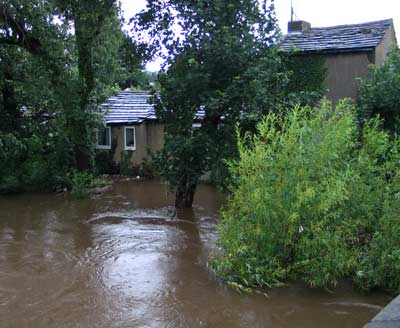
It's been the wettest June on record and today a month's rain fell in 24 hours. Most of the roads into Wakefield were closed because of flooding, large parts of Sheffield and South Yorkshire are underwater and, here at Horbury, the river is as high as I've ever seen it, equalling the levels of November 2000.
 This
evening, when we walked down to the bridge, cars
had pulled
up
and about
40 people were standing in groups watching the flood. One
man told us that, because most of the rain had fallen on the hills to the
west, the river would
continue to rise until about midnight.
This
evening, when we walked down to the bridge, cars
had pulled
up
and about
40 people were standing in groups watching the flood. One
man told us that, because most of the rain had fallen on the hills to the
west, the river would
continue to rise until about midnight.
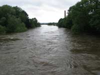
With rushing waters lapping the tops of arches and bow waves frothing over the submerged bridge piers, it felt like being at sea.
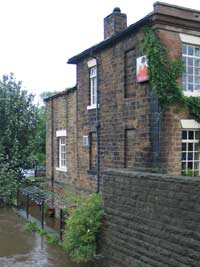
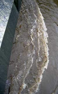
 The
cellars of The Bingley Arms (right) have been
flooded before but today the riverside terrace is under several feet of water
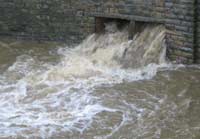
too. As I mentioned last week, the flooded river blocks the outlet of Coxley
Beck, which flows under the forecourt beer garden of pub, so now
an old overflow channel (left), which I believe formed a part of
an old watermill race, of is
roaring out into the canal basin.
The
cellars of The Bingley Arms (right) have been
flooded before but today the riverside terrace is under several feet of water
too. As I mentioned last week, the flooded river blocks the outlet of Coxley
Beck, which flows under the forecourt beer garden of pub, so now
an old overflow channel (left), which I believe formed a part of
an old watermill race, of is
roaring out into the canal basin.
The river is 16 feet above its normal level, the canal 4 feet.
 Water
Under the Bridge
Water
Under the Bridge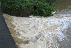 There's
another overflow into the canal nearby (left) which is also running
at full spate.
There's
another overflow into the canal nearby (left) which is also running
at full spate.
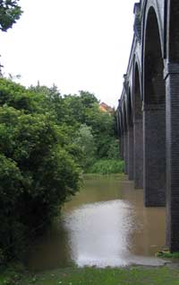
Coxley Beck and Smithy Brook meet a short distance upstream by the old Midland Railway viaduct (right) and, since between them these streams drain a large area of well-wooded farmland, it's not surprising that a pool has developed on the paddock immediately adjacent to their confluence below the arches of the viaduct.