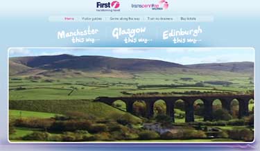
 THIS
IS THE KIND of 'junk-mail'* that I don't mind receiving; an e-mail about the
new First
TransPennine Express Manchester to Scotland service which has a link to
a video clip (left) that
makes me want to travel by rail again:
THIS
IS THE KIND of 'junk-mail'* that I don't mind receiving; an e-mail about the
new First
TransPennine Express Manchester to Scotland service which has a link to
a video clip (left) that
makes me want to travel by rail again:Crook of Lune |
Richard Bell's Wild West Yorkshire nature diary, Thursday, 22nd November, 2007, page 1 of 2 |
THIS
IS THE KIND of 'junk-mail'* that I don't mind receiving; an e-mail about the
new First
TransPennine Express Manchester to Scotland service which has a link to
a video clip (left) that
makes me want to travel by rail again:
 'bigger Windows . . . More room to enjoy the view . . . take a look at the
scene behind the scenery.'
'bigger Windows . . . More room to enjoy the view . . . take a look at the
scene behind the scenery.'
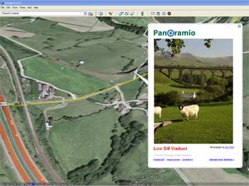
If you return to the page you get a different video snippet of hill country seen from the Manchester to Carlisle line. It looks so familiar to me, especially this view of the old viaduct at Low Gill, looking east towards the Howgill Fells.
Three years ago we walked under this viaduct after following the Lune Valley parallel to the disused railway. This section of the Dales Way through riverside pastures and woodland was one of the highlights of the walk from Ilkley to Bowness-on-Windermere, but the whole route was pretty good, for that matter.
* And I should point out that this wasn't spam, as I book tickets online with TransPennine, whenever we head off to Manchester Airport.
 In
Turner's Footsteps
In
Turner's Footsteps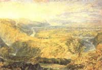 As
you can see from the Google Earth image (right),
the Manchester-Carlisle railway and M6 motorway run close together as they
approach Tebay, where they cut into the foot of Shap Fell
to skirt the eastern edge of the Lake District.
As
you can see from the Google Earth image (right),
the Manchester-Carlisle railway and M6 motorway run close together as they
approach Tebay, where they cut into the foot of Shap Fell
to skirt the eastern edge of the Lake District.
Just beyond the viaduct, to the right in the view above, is a bend on the river called the Crook of Lune, which even Turner didn't have to do too much to make it correspond with his heroically sublime vision of the English landscape. Crook of Lune, Looking towards Hornby Castle, 1817 (left), appeared as an engraving in The History of Richmondshire by Rev Thomas Whitaker.
Too many Crooks! - Thank you to Ron Buchanan who has pointed out 'I think you will find though that the Crook of Lune that JMW Turner painted was the one near Lancaster looking towards Hornby Castle and not this one near Lowgill.' Well, all I can say is that for once the great man missed out on the best view! Although I ought to check out the Hornby Castle Crook before I decide.
We sat on a log beside the river and had a drink overlooking Crook of Lune Bridge, but I didn't follow Turner's example and draw it because this was one of our longer day's walking and it was starting to rain. As we walked up under the arches of the viaduct I spotted a telephone box, more or less in the middle of nowhere, so, as we didn't have a mobile phone at the time, we phoned Barbara's mum just to let her know what progress we were making.
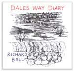
My Dales Way Diary is available from Willow Island Editions.
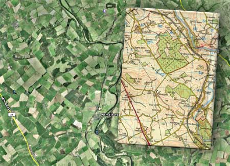
Thirty-two miles north of Low Gill, the village of Armthwaite is a halt on the Settle-Carlisle line. In 1994 I travelled through it on my way to meet geologist Steve Cribb for a tour of the whisky distilleries of Scotland (I get some tough assignments, don't I?) for his book Whisky on the Rocks, for which I supplied the illustrations.
At the time, I was using a notebook with a cover made from a recycled Ordnance Survey map. I was astonished when I realised that the train was making its way up the railway that runs almost along the spine of the book. I could recognise the woods and villages that we passed.
I've superimposed
the notebook on the corresponding stretch of landscape as seen on Google
Earth (above).
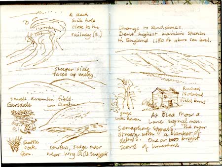 |
Drumlins and SinkholesSeveral dozen distilleries later - and, no, we didn't sample the single malt at each of them - I drew drumlins, sinkholes, fells and a ruined field barn on my return along the same stretch of railway. I've been along the Settle-Carlisle only 3 or 4 times, so I think the chances were slim of me being there with that particular notebook out of the dozens that I've used. |