 |
Heath to the Chantry ChapelMonday, 12th November 2001, West Yorkshire |
![]()
![]()
![]()
![]()
![]()
![]() This Month
Rocks
History
Workshop
Links
Home Page
This Month
Rocks
History
Workshop
Links
Home Page
![]()
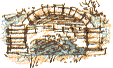 OUR SHORT circular walk from Heath village to the medieval Chantry Chapel on Kirkgate Bridge in Wakefield is short but full of contrasts. We start by crossing the wide open spaces of Heath Common where one or two bushes of Gorse are in flower but we're soon by the busy main road at a spot where the Barnsley Canal once passed under a turnpike road. This end of the canal, where it joins the Calder was filled in when Wakefield Power Station, now demolished, was built.
Belle Vue
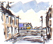 We take an short, unintended detour to Templar Street, one of two streets of terraced houses, of the type celebrated in Britain's longest running television soap, Coronation Street. The street ends abruptly at the railway where a locomotive trundles incongruously past the end of the road.
We take a short cut across a part of town known as Belle Vue, presumably because, before the houses, factories and railway were built there was a sweeping view across the broad valley of the Calder and back towards Heath.
Fall Ings
 The Fall Ings canal basin opened in 1761. When we last came this way in the summer the basin, and the entire towpath network it connects with, were closed because of the foot-and-mouth outbreak.
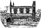 We cross a narrow packhorse bridge dating from 1730 near the Chantry Chapel, first licensed in 1356, on Wakefield's medieval bridge.
Power Station Site
We follow the river back to Heath, passing through scrubby birch woodland on what were the fly-ash lagoons of Wakefield Power Station. The power station site still lies derelict. When it was first demolished the sudden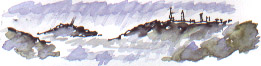 We return via the Half Moon, a cut off meander of the Calder then follow a short stretch of the Trans-Pennine Cycling Trail to return to Heath. There's a view back to Wakefield. In misty rain the buildings are softened and the natural contours of the landscape become more obvious; the sandstone escarpment at the opposite side of the valley at Eastmoor and the isolated tree-covered Lowe Hill in Thornes Park.
We cross the Heath's wide village green surrounded by stone-built houses, the grandest of which is Heath Hall. Visiting in the year that Fall Ings lock opened, the Rev John Mulso wrote that Heath was 'esteemed one of the prettiest Villages in England, a mile or so from Wakefield.'
![]()
Richard Bell,
wildlife illustrator
E-mail; '[email protected]'
![]() Next page
Previous page
This
day last year This month
Nature Diary
Home
Page
Next page
Previous page
This
day last year This month
Nature Diary
Home
Page
![]()