
|
The View from Lepton EdgeThursday, 10th April 2003, West Yorkshire |
![]()
![]()
![]()
![]() Rocks | History |
Workshop |
Links | Home
Page
Rocks | History |
Workshop |
Links | Home
Page
![]()
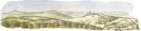
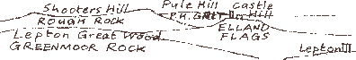
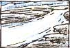
From Lepton Edge, near Huddersfield, you look west towards Castle Hill, three miles away and the saddlebacked ridge of Shooters Hill beyond it. You're looking back in time over Lower Coal Measures rocks laid down some 300 million years ago during the Carboniferous period.
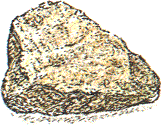
Beyond Shooters Hill, Pule Hill is capped by Pule Hill Grit, which belongs to the Millstone Grit series of rocks. These grittier sandstones dates from the middle of the Carboniferous period, some 320 million years ago.
 Tough
layers of sandstone and gritstone cap the hills and moors. The softer
shales sandwiched between them have been eroded away to create valleys.
It's not quite as simple as that of course because some beds of sandstone
can be found in the valley bottoms.
Tough
layers of sandstone and gritstone cap the hills and moors. The softer
shales sandwiched between them have been eroded away to create valleys.
It's not quite as simple as that of course because some beds of sandstone
can be found in the valley bottoms.
Bread-and-Butter Sandwiches
William Smith (1769-1839), the pioneer geologist who first made the first geological map of England, compared the ridges and vales formed by layers of rock to a plate of bread-and-butter sandwiches.
In this view we're standing on the top crusty layer of a multi-layer club sandwich, looking back over the tilted layers of bread-and-butter (i.e. sandstone-and-shale) below. The Pule Hill grit is the lowest, crustiest, slice of bread we can see.
Pennine Anticline
 The
reason the Pule Hill Grit is now higher than the Greenmoor Rock, a sandstone
that was originally laid on top of it, is that the layers have been tilted
to form an upfold, the Pennine Anticline, in a continental collision that
took place as the supercontinent Pangaea formed some 280 million years
ago. There was further movement along fault lines in the Pennines when
the Alps began to form as Africa started to collide with Europe 25 million
years ago.
The
reason the Pule Hill Grit is now higher than the Greenmoor Rock, a sandstone
that was originally laid on top of it, is that the layers have been tilted
to form an upfold, the Pennine Anticline, in a continental collision that
took place as the supercontinent Pangaea formed some 280 million years
ago. There was further movement along fault lines in the Pennines when
the Alps began to form as Africa started to collide with Europe 25 million
years ago.
Ice Age Erosion
 We
might be looking back 320 million years in time but most of the sculpting
of this landscape has taken place in the last million years, during at
least four advances of ice age glaciers. It's also worth remembering that,
because of worldwide changes in climate, for much of the last one million
years Britain was warmer than it is today, verging on the tropical. It's
thought that tropical weathering might have played a part in the formation
of some of the gritstone tors found on the Pennines, for instance at either
end of the 'saddle' of Shooters Hill. In warm, wet tropical conditions
there might have been deep chemical weathering along the joints and bedding
planes of the gritstone.
We
might be looking back 320 million years in time but most of the sculpting
of this landscape has taken place in the last million years, during at
least four advances of ice age glaciers. It's also worth remembering that,
because of worldwide changes in climate, for much of the last one million
years Britain was warmer than it is today, verging on the tropical. It's
thought that tropical weathering might have played a part in the formation
of some of the gritstone tors found on the Pennines, for instance at either
end of the 'saddle' of Shooters Hill. In warm, wet tropical conditions
there might have been deep chemical weathering along the joints and bedding
planes of the gritstone.
Ancient Rivers
 Sand
and grit were laid down in river deltas in Carboniferous times. Recent
investigations have revealed that different layers of sandstone, for instance
the Elland Flags and the Greenmoor Rock, had different origins. Some sandstones
have a greenish tinge, others are greyish. Analysis of the heavy metal
content reveals that the rivers that supplied the sand originated in different
catchment areas.
Sand
and grit were laid down in river deltas in Carboniferous times. Recent
investigations have revealed that different layers of sandstone, for instance
the Elland Flags and the Greenmoor Rock, had different origins. Some sandstones
have a greenish tinge, others are greyish. Analysis of the heavy metal
content reveals that the rivers that supplied the sand originated in different
catchment areas.
![]()
![]() Next page | Previous
page | This day in 2000
| This month | Nature
Diary | Home
Page
Next page | Previous
page | This day in 2000
| This month | Nature
Diary | Home
Page
![]()