Nature Diary Rocks History Gallery Links Home Page 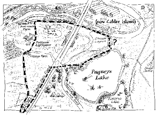 TWENTY-FIVE years ago the Pugneys was an area of rubbish dumps, old gravel workings and opencast mines. We walk from the watersports lake of Pugneys Country Park, south of Wakefield, to the riverside by Cawood's Lagoon, a former gravel pit. NOTE; I'm not sure if there is a public right of way between the two, although there is certainly public access along the rest of the route I've shown.
On the other side of the road, waste from a Victorian soapworks forms a substantial cliff by the River Calder. The rabbit-nibbled turf on the top of the mound includes the leaves of Mouse-ear Hawkweed. A garden escape, Snow-in-summer, has colonised some of the dry slopes.
Before the Denby Dale Road was constructed as a turnpike, one way for pedestrians to cross the river was by the ferry at Boathouse Farm. We follow the path that leads from the farm towards Durker. Grange Farm has adjoining barns constructed in, respectively, sandstone and old handmade brick.
|
 There are oyster shells and fragments of pottery in ashy soil by the Denby Dale Road bridge, signs of a Victorian rubbish tip.
 The Redlands Aggregates Grange Farm quarry has now been landscaped as a grass-fringed lake. Sand, gravel and cobbles were extracted here. A few Wigeon join the Mallards and Tufted Ducks.
 As we near the Denby Dale Road, we stop to look at the pollution in the ditch by the path. It's the kind of pollution that used to feature in documentaries in the 1960s. I don't think I've seen anything as bad for years, except on film from Eastern Europe.