 |
Muncaster FellTuesday, 20th February 2001, Eskdale, Cumbria |
![]()
![]()
![]()
![]()
![]()
![]() This Month
Rocks
History
Workshop
Links
Home Page
This Month
Rocks
History
Workshop
Links
Home Page
![]()
 FELL LANE, a straight track that climbs from Muncaster Castle onto
Muncaster Fell, follows the course of a Roman road which connected the Roman harbour at Ravenglass with the fort at Hardknott Pass.
FELL LANE, a straight track that climbs from Muncaster Castle onto
Muncaster Fell, follows the course of a Roman road which connected the Roman harbour at Ravenglass with the fort at Hardknott Pass. The rough granite drystone walls alongside the track are topped in places by Polypody Fern, which has rusty ochre oval sporangia along the back of some of its fronds. A Spleenwort Fern (Maidenhair Spleenwort?) grows in crevices on the wall along with Ivy-leaved Toadflax. Some parts of the wall are completely covered in bright green moss.
Plantation conifers are underplanted with Rhododendrons which are a speciality of the Sino-Japanese gardens in a sheltered dell at Muncaster Castle below.
Ravenglass
There's speculation in a local guidebook about how Ravenglass got its name but it occurs to me that it might have similar origins to that of Spurn Point, at the mouth of the Humber in Yorkshire which in medieval times was known as Ravenser. The name applied to an island and a village. I seem to remember reading that this came from a Viking term Raven's spur which described a sandy spit of land, similar to the present-day Spurn Point. Perhaps a similar spur of sand dunes marked the entrance to the harbour at Ravensglass in Viking times?Bedrock
 A three-feet deep trench reveals that the subsoil on the hillside is red. The bedrock, where it shows through, appears to be granite. It has pseudo-joints that, here on the fell, are vertical and have a north/south trend.
Volcanoes and Granite
Checking on the geological map, I find that the fell is part of a mass granite which was intruded in Devonian times into layers of volcanic ash from the earlier Ordovician period. These volcanic ashes are described as Andesitic, which, as you might guess, means they are typical of continental collision zones like the present-day Andes, where the ocean floor is plunging deep beneath continental crust, producing volcanic larvas which are ashy and explosive, rather than molten and runny, as they would be where the ocean floor is splitting and spreading (as in present-day Iceland).Triassic Sandstones
A hundred million years after the granite formed it is thought that the whole of what would be the Lake District was subjected to desert conditions during the Triassic period. The ancestral dinosaurs may have left their footprints in the sands that covered the old continental collision zone. But if there were such rocks they have gone today because, about 20 million years ago another continental collision, the one which formed the Alps, pushed the rocks of the Lake District up into a dome. The soft covering of desert sandstones was eroded away from the centre of the dome and these Triassic rocks now form the gentler landscapes of the coast along the western rim Lake District, from St Bees Head to Barrow in Furness.I walk past what the map marks as a 'Mountain Tarn' (to which there is no public access, by the way), but as it is hidden amongst rhododendrons I feel that I could just as well be in the heart of an English country park, in the Dukeries for example.
Mist on the Moor
It takes me half an hour to climb from the castle to the end of the forestry plantation and out onto the open fell. Now the crags loom ahead out of the low misty cloud and I climb over the pinkish granite. The exposed rock in the crags has weathered to grey and is largely covered with lichen, with a few straggly plants of heather growing from crevices. It is furrowed with eroded joints, like the skin of an elephant.
It's surprising how quickly the landscape has changed from Dukeries to plantation to something resembling Dartmoor.
I'm walking over a fine wiry grass, dead and brownish, which I'm sure even the hardy Herdwick Sheep would have difficulty feeding on. There's also close-cropped Bilberry (?), which is totally devoid of leaves at the moment, although the stems are glossy and green. There are clumps of spiky rushes, gorse bushes and, on a slope below me, a large patch of reddish Bracken, which has died back for the winter.
There's a branchy pale grey green lichen which in a few places forms a tennis ball-sized clump. It even grows on some of the older twiggy stems of the bilberry.
I find two pellets which I'm surprised to see are full of seeds, thistle by the look of them, rather than animal remains. They are grey, oval and about one inch by half an inch. Perhaps a Carrion Crow has ejected them here.
Further along, conspicuously placed on a clump of bilberry by the path, there are some Fox droppings. These are clayey and contain a lot of fur and some small pieces of bone. There appears to be a lot of sheep's wool in them.
In the wet flushes around springs the ground is black and peaty with dense growths of Polytrichum Mosses, the sort that look like miniature palm trees.
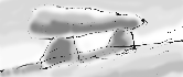 The path I'm on seems to have veered away from the one marked on the map and I've found myself on the top, instead of to the the right of, a small knobbly crag. Below me to my right there's a dolmen that appears to be marked on the map as Ross's Camp.
 As I take the steep slope down to rejoin the main path I disturb a Meadow Pipit, which flies up from the path. This pipit, along with another pipit that I see later, is the only bird that I see on the moor in this mist.
Walking through cloud, I miss the extensive views that the fell offers. I'm glad of an up to date map - the Ordnance Survey Outdoor Leisure 6, the English Lakes, South Western area - and of my compass. Luckily the cloud allows me to see about a quarter of a mile ahead.
As the track winds down past the first group of houses on the hillside, 50 Redwings fly from a spreading Ash tree, chuckling as they fly off.On a south-facing bank at the foot of a Hazel hedge, I see my first Lesser Celandine. In this rain the few flowers are closed up.
Return Journey
It's possible to make this walk across the fell into a round trip by taking the Ravenglass and Eskdale Railway back to Ravensglass from the station at Irton Road at the foot of the fell, but check the times as it doesn't run throughout the year.![]()
Richard Bell,
wildlife illustrator
E-mail; '[email protected]'
![]() Next page
Previous page
This day last year
This month
Nature Diary
Home Page
Next page
Previous page
This day last year
This month
Nature Diary
Home Page
![]()